Doggerland
What existed before history

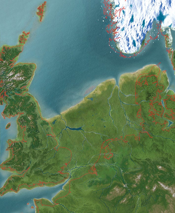
Doggerland, 11,000 years ago. (Olav Odé/ National Museum of Antiquities, Leiden, Netherlands)
Such a weird image. That familiar coastline of East Anglia, Harwich, Great Yarmouth, the Wash, Grimsby – not there. The Channel petering out into rivers. The North Sea stopping around the Scottish border. Britain firmly attached to the rest of Europe.
None of these places had any meaning to the inhabitants of what we now call Doggerland. Ten thousand years ago there was no way of mapping the world, nor any borders. Just nomadic tribes, roaming around fertile parts of Europe, hunting animals and gathering plants to eat, leaving only their tools behind. Doggerland was not a place. And yet Doggerland existed – in fact, it was probably the most hospitable part of Europe, with a mild climate, forests, lakes and rivers.
We know people lived there because in 1931 a North Sea fishing trawler dredged up a prehistoric harpoon. Archaeologists did not understand why it was so far offshore, given people would have been unable to sail very far away from the coastline. When they analysed the peat around it they found it had formed in fresh water. In other words, someone had dropped the harpoon, not lost it at sea.
None of this is terribly pertinent to the latest episode of More Jam Tomorrow, which is about Britain’s relationship with fish. But I find myself oddly fascinated by it – maybe because I’m re-reading Graham Swift’s Waterland. There’s a whole other story about whether offshore windfarms will disturb what remains of the Mesolithics, and whether that matters. But this odd map is a fine memento mori for a world troubled by rising seas and porous borders.
More Jam Tomorrow: Fish is out now. If you like my work, you can tip me at Ko-fi.com.